Florida is protecting and restoring the Everglades with Google AI
Comprehensive effort is underway to protect and restore the Everglades
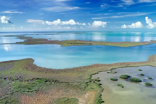
The South Florida Water Management District (SFWMD) is a regional public agency overseeing natural water resources for more than nine million residents across 16 Florida counties, from Orlando to the Florida Keys. At the heart of SFWMD’s mission is a complex balancing act: actively managing water levels among the region’s lakes and canals to prevent seasonal floods or shortages, while restoring the natural balance of the Everglade ecosystem. This includes monitoring and maintaining native vegetation and wildlife along adjacent floodplains of the Kissimmee River, where flood control measures in the 1960s had unintentionally decimated the area’s native vegetation and wildlife populations.
For SFWMD’s team of resident scientists, maintaining the Kissimmee wetlands requires precise measurement of seasonal hydroperiods–the timing, duration, and depths of water coverage along 40 square miles of the river’s adjacent floodplains. The advanced data they receive signals adjustments needed to compensate for heavy rainfall or extended dry periods, while more closely emulating the river’s original natural flow, in turn improving the habitat for native wetland flora and fauna.
SFWMD sought to automate existing methods of monitoring hydroperiods, which requires advanced analytics and data modeling to better depict how overbank flooding affects the Kissimmee Floodplain’s delicate ecological balance.
The Kissimmee River, with the Upper Chain of Lakes, forms the headwaters of the Everglades. The formerly channeled Kissimmee River was restored to a meandering river, making it one of the largest successful restoration projects in history.

As we’ve looked at the available technology over the last 5-7 years, we’ve learned that we need to rely more on AI and machine learning…Google Earth Engine brings some prepared tools, coupled with our existing data, so that we can gain new insights.
Co-creating an enhanced measurement tool, powered by AI
Thanks to extensive collaboration between the agency’s scientists and engineers and Google Cloud, SFWMD now benefits from a new, expanded hydroperiod measurement tool. Leveraging Google Earth Engine, scientists and agency personnel alike access an interactive, user-friendly interface for advanced hydroperiod monitoring across the Kissimmee region.
Combined with automated data processing through other Google Cloud services including Vertex AI, Cloud Run and BigQuery, the Kissimmee River Floodplain Hydroperiod Calculator accelerates overnight water depth rasters and other day-to-day comparative analysis. Results which had previously taken hours, are now tabulated within a minute. The new tool, powered by Google AI, is "phenomenally better than what we had before” said SFWMD CIO, Akin Owosina.
End-to-end development of the SFWMD hydroperiod tool, from initial concepts through full deployment, was completed within an impressive 10-month timeframe. Inputs were balanced across the agency’s science and IT teams–what SFWMD Senior Scientist Lawrence Spencer described as “a great collaboration.”
SFWMD was also grateful for numerous key contributions among the Google Public Sector team, including coaching SFWMD scientists with refining vast volumes of programming code, utilizing Google’s own groundbreaking AI model, Gemini, to achieve timely outputs.
After promising early results from the new hydroperiod tool, the SFWMD is already eager to explore further development, such as enhancing its graphical interface. The agency also envisions expanding this advanced monitoring technology into other South Florida water resources.
Previously, when explaining results from our original hydroperiod tools, I needed to begin every discussion with a whole process of describing functionalities and technical details, especially in meeting presentations. But now, Google Earth Engine makes it much easier to visually present our findings in a concise, interactive format.
About South Florida Water Management District (SFWMD)
The South Florida Water Management District is a regional governmental agency that manages the water resources in the southern half of the state, covering 16 counties from Orlando to the Florida Keys and serving a population of 9 million residents. It is the oldest and largest of the state's five water management districts. Created in 1949, the agency is responsible for managing and protecting water resources of South Florida by balancing and improving flood control, water supply, water quality and natural systems.
Explore more Public Sector case studies and solutions

Generative AI
Sullivan County: Using virtual agents to serve more citizens faster, at any hour of the day

Collabroation / Productivity
Driving cultural transformation with a multi-generational workforce

GENERATIVE AI
How a small Air Force team used Vertex AI to overhaul their manual processes in just 90 days

